")

Making the Invisible Visible
A satellite imagery-based calendar of human impact on the planet
01.10.2021
By Andreas Rothenhäusler
Supervisor: Dr. Gesa Lüdecke
A Picture is Worth a Thousand Words
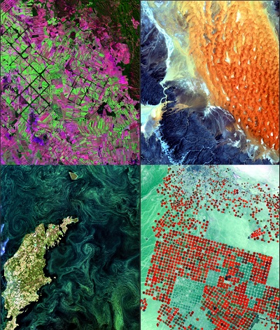
Convinced that this saying is true, my final project is a printed calendar based on satellite imagery. This format allows the user to identify with this message over the course of a year. The calendar is divided into six ecosystems: forests, deserts, mountains, rivers, islands, and coasts. These six ecosystems represent important habitats for flora and fauna and are important for the regulation of the planetary system. Here, the ecosystems can be contrasted with one another, with satellite imagery showing the effects of human impact on the ecosystem in contrast to earlier image data with less human impact. The bird’s eye perspective allows for a better understanding of the scale of anthropogenic impact on the Earth. Since human impact is already evident across large parts of the planet, I selected the title "(im)balanced." This makes clear that the natural balance of nature is changing and that humankind is dominating the planet as a result of its actions. Each month has a title related to the human body. It therefore emphasizes how human interactions with nature also impact on human health.
Technical Background
The Sentinel-2 images used are freely available data from the Copernicus program of the European Space Agency (ESA). Earth 2 observation is used to obtain data for meteorology, weather forecasting, in climate research to monitor marine and air pollution, for disaster prevention, as well as for spatial and landscape planning by observing land use, road traffic, and noise mapping. The Sentinel-2 satellite belongs to the optical remote sensing sensors (in contrast to radar remote sensing). It captures solar radiation reflected from the Earth's surface in the visible part of the light (visible for human eyes) as well as infrared wavelength ranges (invisible for human eyes). Therefore, the subtitle of this project is called "Making the Invisible Visible."
Challenges and Image Selection
A major challenge with optical data is the availability of cloud-free images. For all months, a maximum cloud cover of about 1% could be achieved. It was important to me that the images were as recent as possible (mostly from 2020 and 2021). This underlines the urgency to act and gives a "live" impression of human impact on the planet. For me personally, remote sensing has huge potential to highlight environmental problems. Visualization is often a challenge, especially for global issues. Satellite data artfully show the extent and speed at which humans are changing the surface of the Earth.