")

Mapping and experience. Travelers, geographers and cartographers in the Late Middle Ages
Application 26 - 30 September
30.10.2016 – 05.11.2016
Kartographie und Weltwissen am Ende des Mittelalters
The seminar will take place from 30 October till 5 November. A preparation session will be held on 17 and 24 October at LMU.
Spaces are limit and you are expected to contact Claudia Märtl c.maertl@mg.fak09.uni-muenchen.de by 30 September.
Scholarly interest in the history of geography and cartography has remarkably increased during the past decades. Nowadays research on the representation of the surface of the world is no longer confined to the field of a narrowly defined history of science, but has become a major topic in contexts dealing with religious (and other) mentalities, the tradition and growth of knowledge, or the role of experience in the discovery of the world.
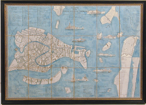
This course will focus geographical and cartographical sources dating from the 13th to the 15th centuries, such as the “world map of Ebstorf”, the “Catalan world atlas”, the world map of fra Mauro which is preserved in the Museo Correr in Venice or the globe of Martin Behaim. Besides these attempts at universal cartography, we shall also consider representations of regional sections, such as the Peutinger map, the map of pilgrim roads to Rome by Etzlaub, or the Liber insularum archipelagi by Cristoforo Buondelmonte, including medieval plans of cities, such as the plan of Venice by Jacopo Barbaro. The following aspects will be discussed: the making of the maps in a technical sense, the underlying mentalities expressed in them, the intentions of the authors and the functions of the maps, the tradition of geographical knowledge and the increasing influence of Greek and Roman geography in the 15th century. Particular attention will be given to the relationship between geography/cartography and experience, taking into account descriptions of travels and maps connected to them, and to the relationship between geography/cartography and historiography, focusing on maps which were integrated into chronicles.
Students will be expected to prepare a case study and to present their findings during the sessions at the VIU. They are also expected to actively take part in the discussion of the sources.
The course will probably be held in German. The following areas will be considered:
1. Die Ebstorfer Weltkarte (13. Jahrhundert) Kira Schmidt
2. Die Weltkarte von Hereford (13. Jahrhundert)
3. Karten im Geschichtswerk des Paulinus Venetus/Minorita (14. Jahrhundert)
4. Pietro Vesconte und Marin Sanudo d.Ä.: Karten in den Kreuzzugsprojekten des 14. Jh. Sabine Krettek
5. Der katalanische Weltatlas von ca. 1375
6. Die seltsamen Karten des Opicinus de Canistris (14. Jahrhundert)
7. Die Weltkarte des Fra Mauro (Mitte des 15. Jahrhunderts) Anna Nierhoff
8. Der Kartograph Nicolaus Germanus und die Rezeption Ptolemaios‘ im 15. Jahrhundert Dominik Knaupp
9. Der „Erdapfel“ Martin Behaims (Ende 15. Jahrhundert) Jessica Kirchner
10. Eneas Silvius Piccolomini, Europa (1458)
11. Eneas Silvius Piccolomini, Asia (1461)
12. Piccolominis Europa in der Schedelschen Weltchronik (Text & Bild)
Anna Schütz
13. Pilgerwege (Der Weg nach Jerusalem bei Matthew Paris, 13. Jh.; Etzlaubs Rompilgerkarte, Ende des 15. Jh.)
14. Die Tabula Peutingeriana
15. Die Venedig-Vedute des Jacopo de’Barbari (Ende des 15. Jahrhunderts)
Sebastian Eigen
• Informationen zum Thema:
http://opac.regesta-imperii.de/lang_de/ (OPAC der Regesta Imperii mit sehr umfangreichen Ergebnissen; Stichwort „Kartographie“: 1338 Literaturtitel, 13. 7. 2016!)
http://www.mgh.de/bibliothek/opac/ (Historische Literatur zum Mittelalter, mit links zu
Rezensionen im Deutschen Archiv und manchmal auch zu Digitalisaten)
http://www.geschichtsquellen.de (digitale Bibliographie zu deutschen Quellen)
Wolfgang Crom / Markus Heinz, Artikel ‚Karten, Kartographiegeschichte, Geschichtskarten‘ auf clio online (http://www.clio-online.de, unter den ‚Guides‘)
Imago mundi. The International Journal for the History of Cartography
(http://www.maphistory.info/imago.html); Jahrgänge 1935-2002 auf JSTOR online, die Aufsatztitel sind auch im Regesta imperii-OPAC aufgenommen